
TransportationX

Safer Seward Highway - Welcome
Please refer to this site for updates, documents, announcements, and to make comments or suggestions.
|

1. Why
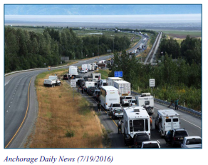
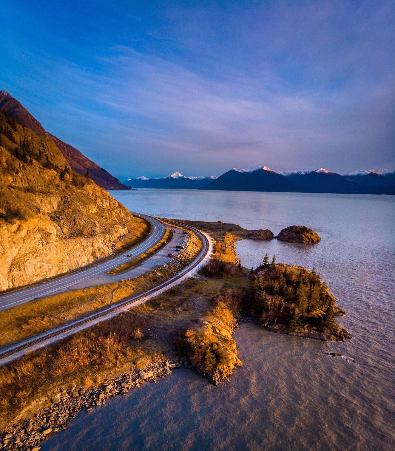
Ask virtually any Southcentral Alaska resident, and they’ll tell you about the time they were stuck in traffic on the Seward Highway for hours because of a car crash up ahead and how they had to watch emergency vehicles squeeze past miles of backed up cars, trucks, and motor homes trying to reach injured motorists.
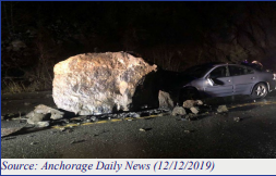
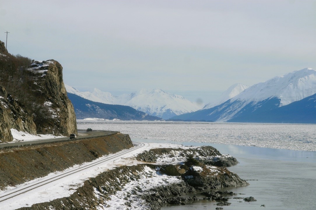
Or maybe they’ll tell you how they had to dodge falling rocks or ice near Beluga Point.
Or maybe how they had to slam on the brakes because a driver decided to pull off the road at the last minute to look for sheep – or beluga whales.
The only way for bikes or pedestrians to get around is within tight shoulders. Sometimes people dash across the highway on foot to try and see animals or sunsets.
In just the past five years (2018-2022), there have been 9 fatal crashes on the Seward Highway Safety Corridor and another 21 crashes where people suffered serious injuries (Safety Corridor Audit 2022, pg. 15). Crash rates have gone down since the area was designated a state Safety Corridor, but serious crashes are still happening, and people are still dying.
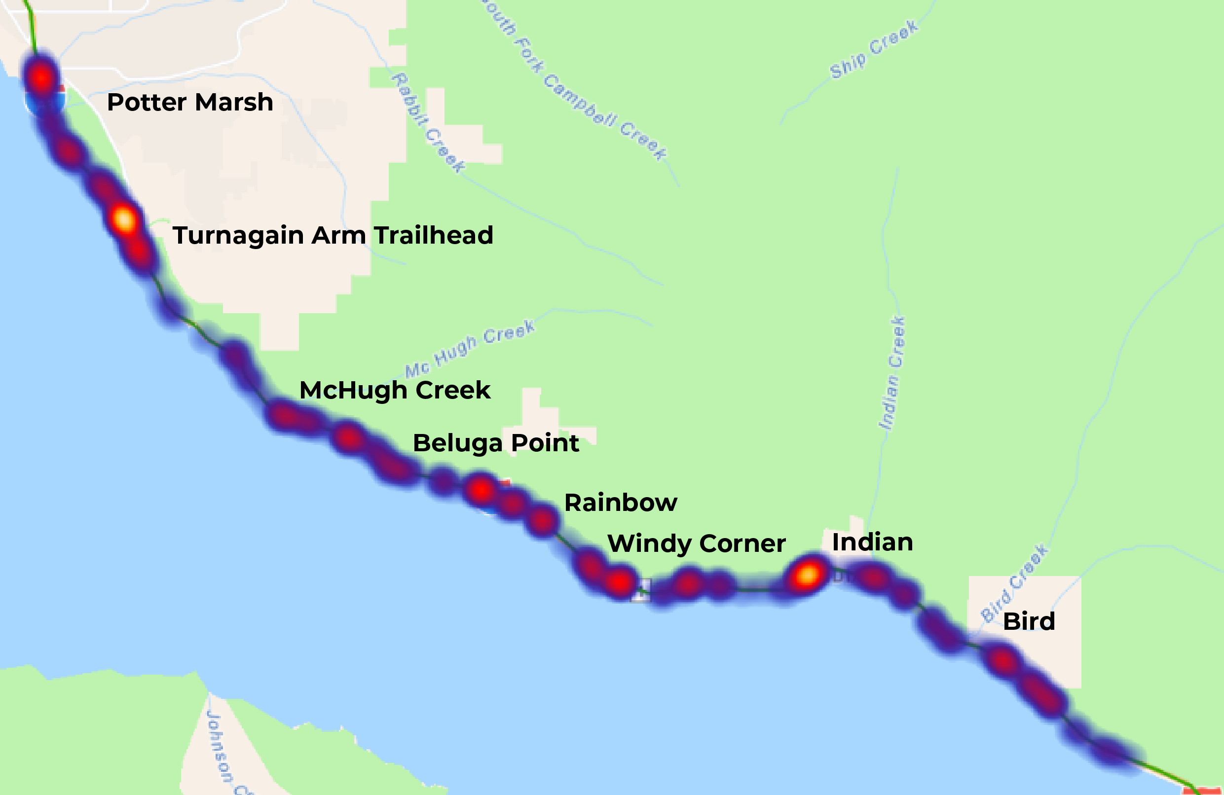
Crash data from 2017-2021
Also, there are a lot of people who illegally cross the railroad tracks to access cool places along the water, which carries severe safety consequences. In a recent study at Beluga Point, the railroad documented almost 1,000 trespassing pedestrian crossings in a day. In 2022, one person died walking along the railroad tracks near Bird Point.
We need to make the Seward Highway corridor safer.
2. What's being done?
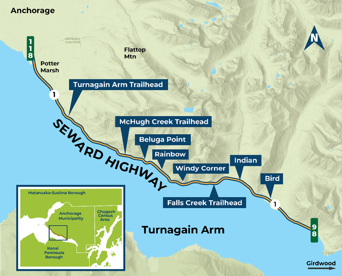
The Alaska Department of Transportation and Public Facilities (DOT&PF) wants to make long-term highway improvements on the Seward Highway between Rabbit Creek Road (MP 118 near Potter Marsh) and Bird Flats (MP 98) to improve safety and eliminate the need for a special Safety Corridor designation.
We’re in the process of identifying solutions. And we’re thinking big picture – a comprehensive solution that will last.
One option is to build a three-lane highway with alternating passing lanes and a separated multi-use pathway.
Another option is to build a four-lane divided highway also with a separated multi-use pathway. This could have a barrier or a median in between lanes.
Either of these options could be designed for travel at 55mph or 65mph. Improvements could be built quickly, depending on funding, or spaced out over a longer timeframe.
We could also choose to do nothing and just leave the highway how it is now.
Honestly, though – this is your opportunity to tell us what we need to do to fix the corridor, once and for all.
3. History
Haven’t we been here before?
Yes…and no.
In 2006, the highway between Bird and Rabbit Creek became Alaska’s first Safety Corridor due to the high rate of fatal and major injury crashes. A Safety Corridor is an area with higher than average serious and fatal crashes. The designation means DOT&PF and the Department of Public Safety are tasked by law to reduce crashes through education and enforcement, and DOT&PF is responsible for identifying road project solutions. This corridor will soon be the last safety corridor in the state as all the others have been decommissioned or are on their way to being decommissioned.

The good news is we’re taking all the good ideas and information from those previous studies to think big and come up with practical solutions that consider multiple uses and multiple benefits.
4. Where we are now
DOT&PF restarted the environmental assessment process in 2022 when the corridor changed from 4 miles to 20 miles. But that’s OK!
Today, we’re working on an updated National Environmental Policy Act (NEPA) environmental assessment that considers multiple ways to reduce the number of crashes permanently.
We’ve proposed a “purpose and need” statement, which is the basis for everything moving forward. If a proposed alternative doesn’t meet the purpose and need, it doesn’t fly. (Sorry, all you future fans – flying cars are not an alternative being considered.)
We’re looking at options – alternative solutions – to meet the purpose and need of the project. We’re also looking at the area around the corridor to see what might happen to the natural and built environment if any of the alternatives were to be built.
Once we have alternative solutions, we’ll ask you what you think. Are we on target? Are we missing anything? Did we forget something? You’ll help us fix this problem!
5. Opportunities... and Challenges
We know there are no easy fixes, but there are opportunities.
We are working with a group of agency, organization, and community representatives to help us figure out some of the thorny issues. This corridor has so many unique challenges, just the steep mountains of the Chugach State Park on one side and the waters of the Turnagain Arm on the other are challenging enough, to then add on the diverse use, the railroad and recreation that happens all throughout. We are asking them to help us identify issues and ways we can compromise…all with the goal of a safer Seward Highway in mind.
We know there will be things that folks like about the project – and things they may not like as much. It’s really hard to be all things to all people, but we’ll do our best to make the highway safer for everyone.
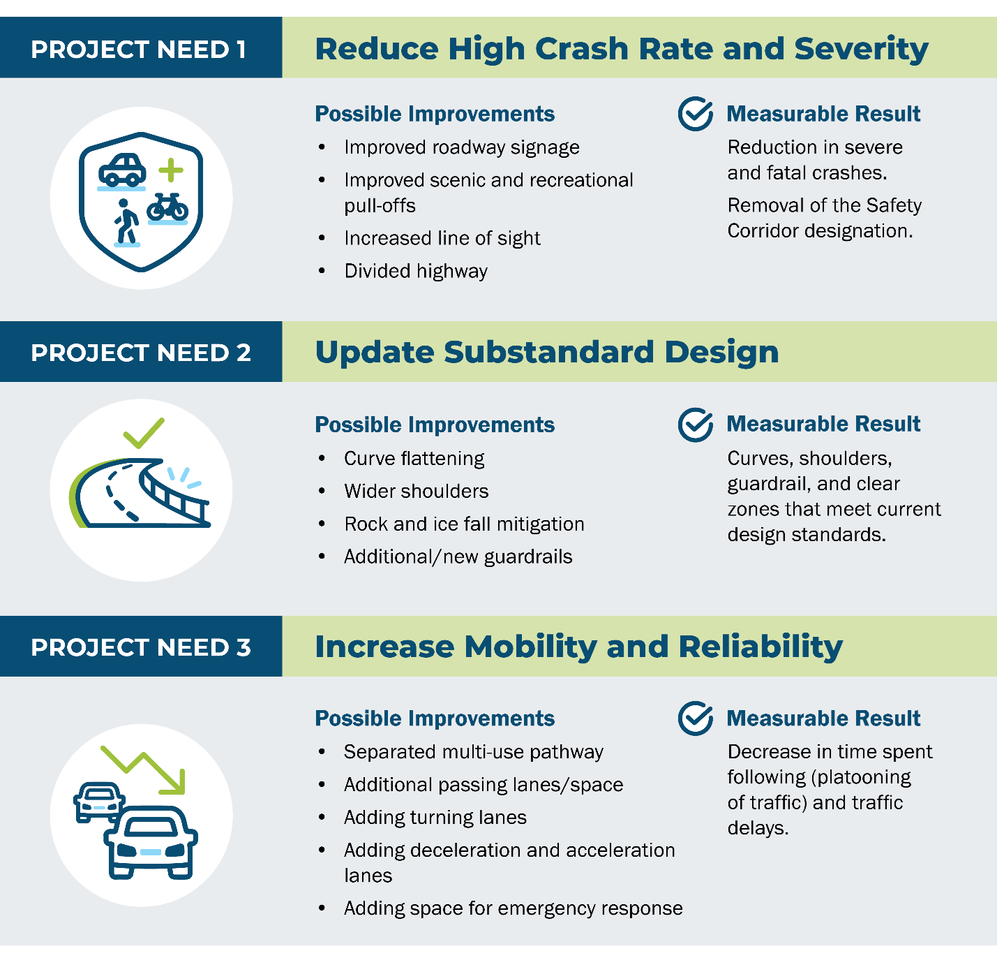
6. Project Goal
How will we know if we’ve succeeded?
The number one goal is to reduce the rate of serious and fatal crashes on the Seward Highway. We want to make the highway safer for everyone.
If we reduce serious crashes, we can remove the “safety corridor” designation. That would be a huge win for Alaskans, not just for today but for years to come.
Increasing mobility and reliability is another key project goal. From cyclist to commuters to emergency responders, everyone can access what they need, and the conflicting needs are minimally going to impact each other. Having access and the reliability of access we’ve heard is very important and we
think it is as well.
7. What we've heard so far
Did you send comments in for one of the previous projects? Never fear! We still have them!
One of the big things we heard is we were looking at too small an area. A fix for two miles at Windy Corner wasn’t going to cut it. Think big! Based on your feedback, we’re now looking at a 20-mile-long corridor, between Rabbit Creek and Bird Flats.
We also heard the highway should be for more than cars, trucks, and RVs. The new alternatives will all include a separated, non-motorized path to keep walkers and bikers safe.
And the big question – can we keep the improvements in the existing highway right-of-way? Likely not. With the priority of keeping people safe, we’ll need to make changes to the curves to improve sight distance, add space along the shoulder to protect the road from falling rocks and ice, and keep a separated distance from Alaska Railroad Corporation tracks. (Don’t walk on or across the tracks, please!)
Importantly, we heard you say you want to keep the area’s scenic character. As we develop alternatives, we’ll look at how changes might affect views and look for ways to avoid and minimize impacts to our beautiful Alaska surroundings.
8. Schedule
The team is working hard to move this project forward. The quicker we can make improvements, the quicker we can have a safer Seward Highway for all. But there are important steps needed to complete the NEPA process, and we want to make sure we are doing our best and not missing anything.
-
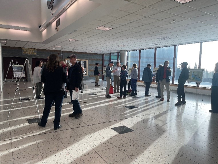
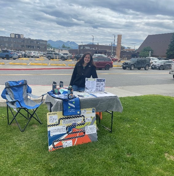
SCOPING – We had a scoping period earlier in 2023 to hear what you all had to say and start forming the purpose and need statement. This included an open house, the launch of our website and online materials, a public comment period, and lots of data and information collected by our environmental and engineering teams.
-
CONCEPTS – This is where we are now. With all that information and data collected, we’ve been able to start sketching some ideas. We have an involved stakeholder working group that represents many local and federal agencies and community organizations to help us refine our ideas. We now have a few pretty good options that we are looking forward to sharing with you all in December at our public meetings.
-
DRAFT EA – After the concepts have been further refined, we will go back and do a bunch of environmental analysis to see what the environmental impacts would be. This is where we start writing our environmental assessment (EA) to record all the information and reasons why the team did not move forward some options and why we moved forward others. This document will take us quite a while to write but we expect it to be complete around November 2024. Will you get to take a look at the draft? Absolutely! We will hold public meetings and comment period so you can let us know what you think.
-
FINAL EA – The final step in NEPA is a final EA document. After we hear from the public and the agencies and make any final changes, we will have a final EA document. Because of the size of this project, the team will also develop a funding and phasing plan.
This may seem like a lot to go through to finally get to design and start digging dirt, but this is an important process that takes a lot into consideration to make sure we are doing the best we can and thinking about all the parts and pieces beforehand.
-
DESIGN & CONSTRUCTION – Once NEPA is complete, there is still a lot of work to do. We will be looking for ways to get construction started rapidly in 2025 so that we can offer some safety improvements in the corridor as soon as possible. Construction will be most likely broken up into segments. This will help us not impact traffic too much as well as help us afford the project. If these improvements are going to meet our needs for the long term, it is worth taking the time to make sure it is done right!
9. Give Feedback
Now, we have a big favor to ask of you. We need to hear from you. This is a community project that impacts a lot of people. The commuters, the recreators, the drivers, the residents, the visitors: we need you! How do you use the highway? What are some things we should consider? What would you like to see? What features do you use? Do you drive through or stop along the way?
We want to hear all of it. Contact the team.
Join our mailing list for updates as we move forward and the latest news on ways to give us feedback.
TransportationX For more information, check out DOT&PF’s TrX Program (arcgis.com) page. |
The environmental review, consultation, and other actions required by applicable federal environmental law for this project are being, or have been, carried out by DOT&PF pursuant to 23 U.S.C. 327 and a Memorandum of Understanding dated April 13, 2023, and executed by FHWA and DOT&PF.
Project Information
Public Meeting Links ![]()